Building The Future
Innovation
innovation
Building the Future
through Innovation
At Blue Water Aquatics, we’re committed to innovation, technical advancement, and continuous research to deliver the best value and service.
One of the most exciting developments in the field of vegetation management is drone-based multispectral imaging, which has enormous potential to enhance our operations.
Drone-Based Multispectral Sensing and Imagery Drone-based multispectral sensing and imagery is transforming decision-making in agriculture. Farmers have been using the technology for years to assess the health of their crops and now governments and universities across the globe are studying its application in aquatic vegetation management.
Just as farmers want to see how healthy their crops are, lake managers want to see the state of target vegetation is after treatment.

Play Video
Drone-Based Spectral Sensors Provides Real-Time Data on Targeted Vegetation Stress Levels. This Technology Allows Users to Deliver Cost Effective, Targeted Treatments and Spectacular Data on Our Results.
How Do Multispectral Sensors Work?
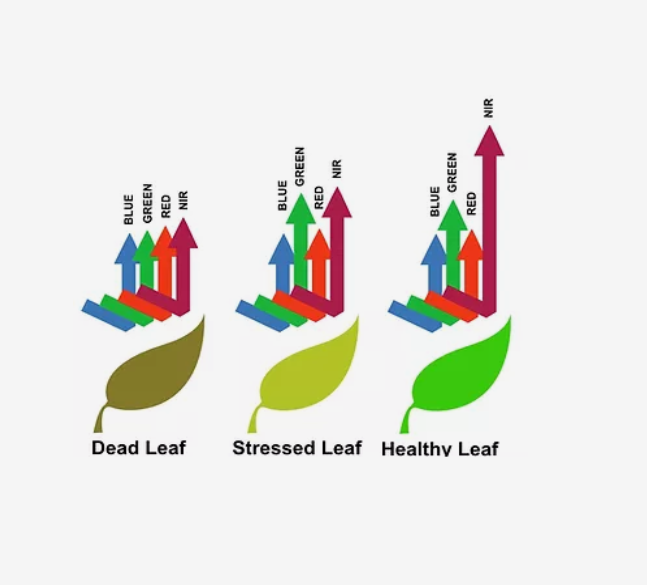
Multispectral sensors are instrumental in plant health and management. They collect visible wavelengths of light as well as near-infrared (NIR) and red edge wavelengths. These narrow spectral bands (40-60 nanometers each) show the structural index of a plant and spot subtle changes in reflectance.
Hyperspectral sensors can also detect the type of crop or weed growing because species leave unique fingerprints or “spectral signatures” in the electromagnetic spectrum.
How Multispectral Imaging Benefits Waterways
Multispectral sensors enable lake managers to identify stresses early
on—when decisions can still be made to re-treat or wait and assess, thereby preventing a costly overuse of herbicides, and limiting the number of herbicides added over time to waterways, which has significant benefits for the environment.
Our motto is “capture data, analyze data, act on data!”
Another advantage of aerial imagery is its ability to provide a bird’s eye view of your treatment area. A single image provides you with access to rich data about your target vegetation without having to fire up a single air boat or ATV. That means less disruption of the waterway, as well as less time, fuel expenses, and hassle for you.


Making Sense of
the Data
Of course, you need to be able to interpret this information to use it and you must have access to the right data at the right time.
We use professional grade agricultural analytics tools, reporting, and API integrations to interpret our images and transform them into useful, actionable data.
It’s clear that aerial and spatial imagery is providing several valuable insights that will impact our industry.
Contact us today to learn more about drone-based multispectral imaging and how it can benefit you.